Last updated: November 27, 2022
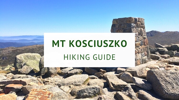
Mount Kosciuszko in the Snowy Mountains in New South Wales is Australia’s highest point, peaking at 2,228 metres above sea level.
While Mt Kosciuszko is primarily known as a busy ski destination during winter, the area is also a popular spot for hiking and mountain biking during the warmer summer months.
This Mount Kosciuszko hiking guide describes the different walking tracks that take you to the summit of Australia’s tallest mountain, offering breathtaking views of Kosciuszko National Park.
Quick navigation:
History of Mount Kosciuszko
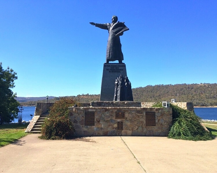
Mount Kosciuszko was discovered and climbed in 1840 by Sir Paul Edmund Strzelecki, a Polish explorer and scientist who surveyed large parts of NSW, Victoria and Tasmania.
Strzelecki named the mountain in honour of Tadeusz Kosciuszko, a Polish-Lithuanian statesman and military leader.
In later years, it was determined that the mountain peak known as Kosciuszko was actually lower than its neighbour Mount Townsend.
In 1892, the NSW Lands Department decided to swap the names of the mountains so that Mt Kosciuszko could keep the status of being the highest peak in Australia.
Mount Kosciuszko is part of the Australian Alps, which consist of the Snowy Mountains and the Victorian Alps.
The Snowy Mountains region is located in New South Wales and the ACT, and the Victorian Alps region is located in eastern Victoria.
| Snowy Mountains | |
|---|---|
| Elevation: | 2,228 m |
| Highest Point: | Mount Kosciuszko |
| Parent Range: | Australian Alps |
Where to Stay in the Snowy Mountains
The best places to find accommodation in the Snowy Mountains to climb Mount Kosciuszko are Jindabyne, Thredbo, Perisher and Charlotte Pass.
Thredbo, Perisher and Charlotte Pass are situated within Kosciuszko National Park, which has a vehicle entry fee of $29 during the peak winter months (from June to October) and $17 during the rest of the year.
The Mount Kosciuszko summit and Main Range walks both start at Charlotte Pass. Thredbo is the starting point for the shorter and easier Mount Kosciuszko walk.
1. Jindabyne
Located just outside Kosciuszko National Park, Jindabyne is a small town overlooking the man-made lake with the same name.
Jindabyne is a popular year-round holiday destination with lots of things to do, such as mountain biking, bushwalking, horse riding, fishing and kayaking.
Lake Jindabyne was formed in the 1960s as a result of the construction of the Jindabyne Dam on the Snowy River.
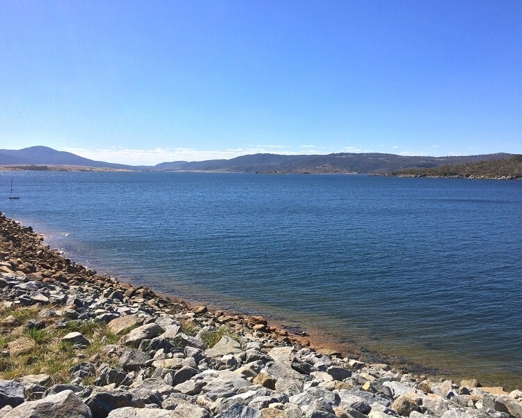
The dam was built as part of the Snowy Mountains Scheme, Australia’s largest hydroelectricity and irrigation complex, providing electricity and additional water to regions further inland.
To get to Jindabyne, follow Kosciuszko Road from Cooma for about 50 minutes (60 km). From Jindabyne, it’s only a half-hour drive to Thredbo.
Rydges Horizons Snowy Mountains.
2. Thredbo
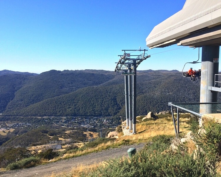
Thredbo is the most convenient and also most pleasant spot to stay, as it’s the starting point of the Thredbo to Mount Kosciuszko walk.
This track starts with an exciting ride on the chairlift, located in the centre of town. Thredbo has a friendly atmosphere with various hotels and restaurants to choose from.
To get to Thredbo, turn into Alpine Way in Jindabyne and stay on this winding road for about 30 minutes. Turn into Friday Drive, which takes you into town past all the hotels and shops.
Candlelight Lodge.
3. Perisher and Charlotte Pass
Perisher is the largest and most popular ski resort in Australia, with numerous ski fields and lifts.
To get to Perisher, follow Kosciuszko Road from Jindabyne for 30 minutes. Charlotte Pass is another 10 minutes drive further west and is the starting point of the Summit and Main Range walks.
It’s important to point out that Perisher and Charlotte Pass aren’t very lively during the off-season.
So, if you’re looking for a bit more atmosphere and more things to do, Thredbo would definitely be a better choice.
Smiggins Hotel and Chalet Apartments.
Walking Tracks to the Summit of Mount Kosciuszko
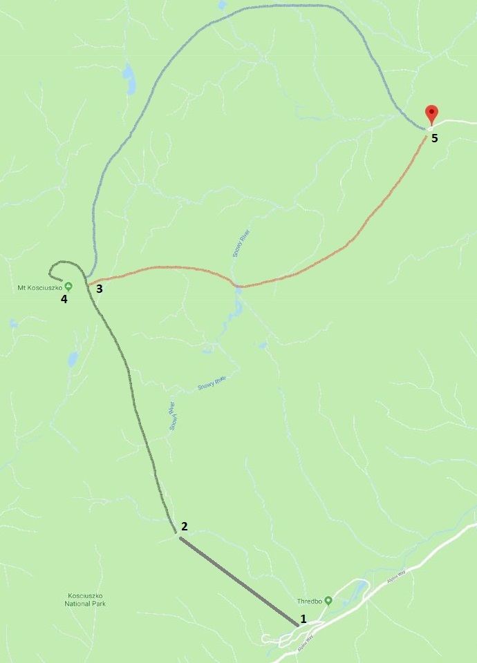
There are three main walking tracks that lead to the summit of Mount Kosciuszko:
- Thredbo to Mount Kosciuszko Walk (13km return)
- Mount Kosciuszko Summit Walk (18.5km return)
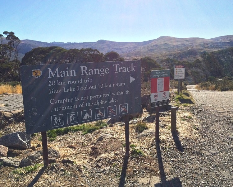
- Main Range Walking Track (22km circuit)
The shortest is 13 km long, and the most challenging one is a 22 km circuit walk. All three walking tracks intersect at Rawson Pass, close to the summit of Mount Kosciuszko, so combining sections of the walks is an option.
There is, in fact, a fourth walking track to the peak of Mt Kosciuszko. The very steep 15 km long Hannel’s Spur Track is the original route that Strzelecki followed in 1840 to reach the summit.
The badly overgrown Hannel’s Spur Track is Australia’s biggest vertical ascent of 1800m and is really for experienced hikers only.
The map below gives you a rough indication of where the three main walking tracks are located.
The Thredbo to Mount Kosciuszko walk is marked in black (including the chairlift ride at the start), the Mount Kosciuszko summit walk is marked in red, and the Main Range track is marked in blue.
The second part of the Main Range walk is essentially the Summit walk back to Charlotte Pass, making it a circuit.
- Thredbo Chairlift
- Eagles Nest restaurant and start of walking track
- Rawson Pass intersection
- Mt Kosciuszko Summit
- Charlotte Pass
Be mindful that even during the warmer summer months, the weather in this area can be extreme, with hot and cold days, strong winds, rain, and snow.
UV levels can also be extreme, even on cold days.
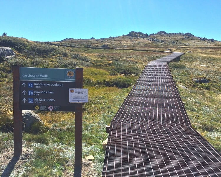
1. Thredbo to Mount Kosciuszko Walk
The shortest, easiest and most popular walking track to the top of Mt Kosciuszko starts at the Kosciuszko Chairlift in Thredbo.
While some sections along this walk are steep, most of the walking track consists of a comfortable metal walkway.
Kosciuszko Chairlift
You can buy a one-way ticket and make your back to the base via a walking track or purchase an all-day pass. While the trip with the chairlift is a bit pricey, it’s quite an adventure in itself.
The best option is to buy an all-day pass online in advance, which is cheaper and easier than buying at the ticket counter.
At the top are two restaurants where you can have a drink and some food, while enjoying great views of the surrounding area. The top restaurant, Eagles Nest, is Australia’s highest restaurant.
The actual walking track starts right behind the chairlift station.
Lake Cootapatamba
One of the most interesting sights along this walking track is Lake Cootapatamba, a post-glacial mountain lake located 800m below the summit of Mt Kosciuszko.
Lake Cootapatamba is one of several lakes in Kosciuszko National Park, created by a natural damming process.
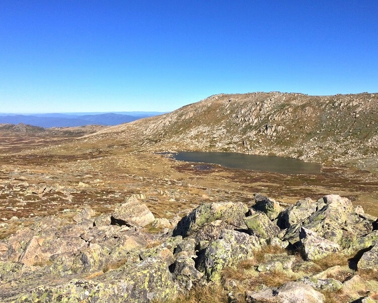
The lakes are the highest in Australia and have no fish, are very low in nutrients, and are covered with ice in the winter months.
Rawson Pass
Rawson Pass is where the Summit Walk on the old Kosciuszko Road meets the Thredbo to Mt Kosciuszko walking track. The last section to the summit starts at this Rawson Pass intersection.
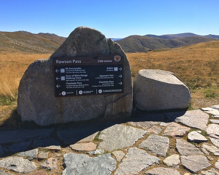
This is also the location of Australia’s highest public toilet.
It was built in 2007 to deal with the increasing amount of hikers and cyclists visiting the mountain each summer.
Mt Kosciuszko Summit
The walking track winds itself around the summit of Mt Kosciuszko until you reach the very peak, the perfect spot for a picnic and, of course, the obligatory selfie.
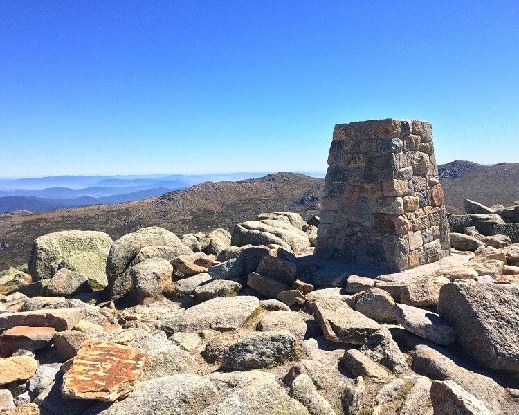
The views of the surrounding landscape are breathtaking and make you feel very small. Keep an eye out for Mount Townsend, officially only 18 metres lower than Mt Kosciuszko.
| Thredbo to Mount Kosciuszko Walk | |
|---|---|
| Distance: | 13 km (return) |
| Time: | 4-5 hours (depending on stops) |
| Grade: | Moderate / hard |
2. Mount Kosciuszko Summit Walk
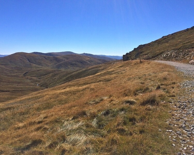
The 18 km Mt Kosciuszko summit walk starts at Charlotte Pass, at the end of Kosciuszko Rd. The longer Main Range walking track starts at the same location.
Until 1977 it was possible to drive from Charlotte Pass to a point past Rawson Pass, but the road was closed in that year due to environmental concerns. The track is open to hikers and cyclists only.
Cyclists will need to leave their bicycles at Rawson Pass and complete the last stretch to the peak of Mount Kosciuszko on foot.
The track crosses the Snowy River bridge and passes the Seaman’s Hut, a small cottage on the road to Mount Kosciuszko.
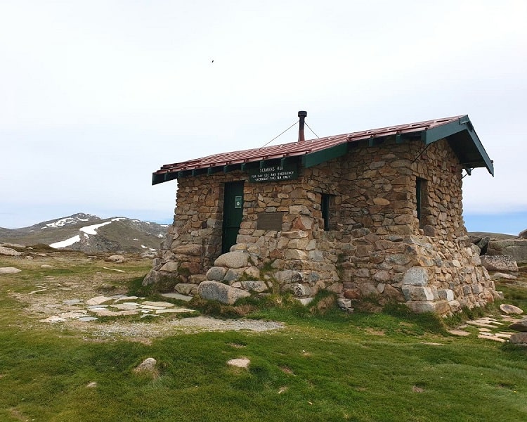
It was built in 1929 by the parents of a skier who died during a blizzard the year before.
The purpose of this hut is to provide emergency shelter to those who need it to prevent the recurrence of a similar tragedy.
| Mount Kosciuszko Summit Walk | |
|---|---|
| Distance: | 18.5 km (return) |
| Time: | 6-7 hours (depending on stops) |
| Grade: | Hard |
3. Main Range Walking Track
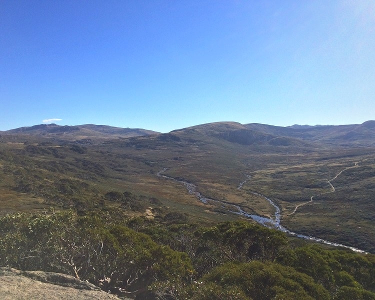
The Main Range walking track is a full-day outdoor adventure, bringing you the best of the Australian Alps scenery.
It’s the length that makes this once-in-a-lifetime walking track challenging, but the track overall is reasonably flat and well-maintained.
The walk crosses the Snowy River twice and offers panoramic views of several alpine lakes along the way.
A major highlight is Blue Lake, one of only four cirque lakes on mainland Australia. In 1996, Blue Lake and its surroundings were recognised as a wetland of international importance.
| Main Range Walking Track | |
|---|---|
| Distance: | 22 km (circuit) |
| Time: | 8-10 hours (depending on stops) |
| Grade: | Hard |
Hi, I am planning to do a day hike in early January (the shortest route 13 km). How do I go about getting a guide (group tour)?
Hi Dorene,
I’m not sure if there are guided tours for hikes up to Mount Kosciuszko. But if you’re concerned about getting lost, there’s no need to be. It’s a well-maintained path, very easy to follow, and there will be lots of people around.
I visited Mt Kosciuszko a few years ago. I chose the Thredbo to Mt Kosciuszko walk by chair lift. it is quite pricy for 4 of us; $49 pp now which is almost $200.
If without taking a chair lift, the only challenging section is from the Thredbo to Eagles Nest. From the Eagles Nest onwards, it is quite flat.
This time, I would like to try to go via the Summit Walk. Is there any difficult section in this routine?
Hi there,
The Summit Walk isn’t much harder than the stretch between Eagles Nest and the summit; it’s just longer (18.5 vs 13 km).
Make sure you bring food and water, good hiking shoes, and check the weather forecast before you go.
My hubby and I are planning to do the Mt Kosciusko Summit Walk in mid May. Are we leaving it too late for the walk? Don’t mind the cold but don’t want to get lost in snow.
Hi Joy,
May is a bit of a hit and miss, but you’re probably going to be fine. Cold for sure, but heavy snow is unlikely.
Hi,
We are a small group of 3 boys planning on doing the main range walk during Easter Break 2022, i.e. from 15th April to 18th April.
Could some of the experienced hikers recommend or share any tips please?
Hi Ragz,
Most important thing is to prepare for all kinds of weather. Warm, cold, dry, windy, rain, snow, you have to prepare for everything.
The hike itself is very doable for young and fit people. Make sure you bring plenty of water and food.
Hi there,
We invite all to visit our website http://www.mtkosciuszko.org.au where you will find valuable information about the conquest of Mt Kosciuszko, the highest peak of Australia, and about Paul Edmund de Strzelecki, the explorer who gave the mountain its name.
Thank you.
What should we pack for the Thredbo to Kosciuszko walk (March hopefully) and do you think it’s comfortable for a 7 yr old?
Hi Sandy, it’s always best to prepare for cold and windy weather in the Snowy Mountains. Wear multiple layers so that you can always take one or more layers off when it gets warmer during the day.
The track to Mount Kosciuszko from Thredbo is well maintained and injuries are highly unlikely, but a small first aid kit is always a good idea. Definitely bring a good amount of water, and a couple of energy bars, pieces of fruit and perhaps some sandwiches to keep you going during the hike.
Kids that age can certainly do this walk, but everyone is different. It will depend on how much hiking the child has done and if he or she is comfortable and happy being outdoors for quite some time. It’s a fun and safe hike, but it’s also very long and a young child needs to be mentally ready for that if you know what I mean.
Hi, great guide!
I’m planning on doing the hike for the first time late December. Trying to work out whether to do the Thredbo to Mount Kosciuszko or the Mount Kosciuszko Summit Walk. Which would you recommend in terms of best scenery? Outside of scenery and distance, are there other considerations I should factor into my choice?
Thanks,
Sarah
Hi Sarah,
The scenery is actually quite similar, with the main difference being that the Mount Kosciuszko Summit Walk is mostly on an old gravel road, and the Thredbo walk has long sections on boardwalks.
Choosing between the two walks will mainly depend on how much time you have and how much you want to hike. Apart from the distance, there is not much difference in terms of difficulty. You may even want to consider combining both, if you have someone available to pick you up at the other end.
Have fun!
Hi!
Do you think this hike to the summit from eagles nest is possible first week of June? That’s without snow shoes.
Thanks
Yikes!
I personally wouldn’t but anything is possible of course. It’s definitely going to be cold, but snowfall is a bit unpredictable. Most of that walk though is on boardwalks so even if it snows a little the track should still be walkable.
Let us know how you go.
Thanks for the great information. Heading there next week.
Del
Enjoy, it’s beautiful out there!
Hi there,
Great information here. We’re really keen to head to Kosciuszko for some hiking soon. We’ll definitely be using your guide.
Thanks in advance.
Cheers, Dan & Beck
Thanks guys, and hope you have a great time in the Snowy Mountains. It’s beautiful out there.
I like it. I have done the walk from Thredbo. The Main Range Track looks quite good. I was contemplating the walking track via Hannels Spur.
That’s awesome David. The Main Range track is a great adventure, so that would be a good excuse to go back to the Snowy Mountains one day!
Hey there, great to read the article.
Could you please advise if walking in December to the summit or to Blue Lake via the Main Range Track would require to include any precautionary items like snake protection gaiters etc. in list of items to carry due to the summer season. Not sure if required.
Hi there, to our knowledge snake bites are rare in the Mount Kosciuszko region, but there’s nothing wrong with extra protection for peace of mind. Another thing to consider is the climate there. Weather conditions can change rapidly, from cold to warm, and vice versa, not to mention the strong winds. It’s best to wear a few layers of clothes that you can take off during hiking when it gets warmer. The sun can also be very strong, so make sure you bring sun protection.
Have a great trip!